 Taking a day off of the blog seemed odd. Since we were “rerunning” our travels in reverse, it reminded me of the days when folks worried about the music of John Lennon and the like, suggesting that if you replayed the music backwards it would be giving subliminal messages. No hidden messages here: just great pictures and great memories.
Retracing our steps though was a necessity given the limited roads in Alaska. To travel by ferry from Valdez to Skagway would be about 250 miles. To drive there is 504 miles. Since Valdez (as was Seward) and Skagway are located on the Gulf of Alaska, there are no roads between them. One has to retrace steps, travel north to a city that is a junction of multiple Alaskan roads and then head in a southerly direction to the next peninsula. In fact, in order to travel from Valdez to Skagway, we not only had to travel 254 miles north to Tok,
 we then had to leave the U.S., travel through the Yukon Territory, a small portion of British Columbia and THEN re-enter the U.S. approximately 18 miles from Skagway. When one looks at the map, there is no way the Skagway, Juneau and other barrier islands should be part of Alaska. We would have loved to know the negotiator of that deal. It all goes back to the Gold Rush days. In fact, some of the disputed boundaries with Canada ended up going before an international tribunal back in the Go
 ld Rush days. The U.S., for obvious reasons wanted the land. And, the rest of the story is that indeed, the U.S. was victorious in its quest for the land in question.
Heading back from
 Valdez, we did take the time to take a loop road that was an offshoot of our twice-traveled road. Called the Copper Center Loop, we quickly found ourselves in days gone by. It was definitely a tourist trap for vacationers on their tour buses. In reality, however, it was a ghost town. They had a museum (and annex!) but essentially the entire town was a museum. There were remnants of an old jail with the Wrangell Mountains in the background. This town was conceived during the Gold Rush Days and died when the rush was over.
 We spent the rest of Friday traveling as far as possible. To those of you reading this, 504 miles doesn’t sound like an impossible trek for one day. These are Alaskan, Yukon and British Columbia roads however, and there is nothing fast about them. We hit patches of gravel, potholes, heaving and the like that slowed our speeds to 30 and 40 miles per hour.
We ended Friday in the Yukon at a provincial campground called, “Lake Creek”. For $12 you can have the site. Everything is on an honor system. The sites lack electricity or water, but make up for it with the natural beauty and the privacy afforded by the trees, large buffers and large sites.
Saturday morning we were on the road again, destination Skagway. We
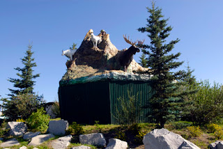
 stopped at a bakery in Haines Junction we had visited two weeks ago and indulged in a couple delicious pastries. We photographed the town “monument” which was a pedestal with re-creations of animals found in the region. We also snapped a great street sign that was embellished with an assortment of antlers. Quite unique and not something you
 will find in an average American subdivision, to be sure.
Once again, we traveled through White Horse YT, the capital city. Filling our tank we paid $4.12 per gallon. Gulp. Twelve miles out of town we headed south on the South Klondike Highway. On this short stretch of 98 miles we would travel through the Yukon Territory, British Columbia and Alaska. It may have been only 98 miles, but it was chock full of incredible sights. This road did not exist until 1978. Prior to that, if you wanted to visit Skagway Alaska, you either took a boat or a plane. On the west side of the southbound road were the St. Elias Mountains and on the east side were the Cassiar and Coast Mountains.
Our first treat was a placed called, Emerald Lake. So unique was the color
 of this water, we found ourselves mesmerized. The incredible color is created by blue green light waves being reflected off the white sediment in the lake bottom. Called marl, it consists of decomposed shell and clay, usually found in shallow, fresh water lakes that have low oxygen levels during the summer months. Well, we’re not sure about the low level of oxygen in the lake, but when one first catches a glimpse of the water, it is enough to take your breath away.
It’s so hard to believe that this road faces impossible weather in the winter. The average January high temperature is –4 F! This is such stark contrast to the 75-degree weather we are enjoying today. Perhaps days like this with beautiful blue skies and pleasant temperatures are what keep people living here. Speaking of that, on this stretch of 98 miles, there are really only two towns. One is called Carcross (named for the caribou crossings that take place in the fall). The other is Skagway. Their combined population is 1,300 people. It might take a bit to get to know your next door neighbors if you lived on the South Klondike Highway.
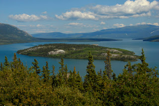
 We entered British Columbia and our next view was of Windy Arm Lake. This extremely long lake twists and turns as its name implies. It also is speckled with small islands. One was called Bove Island, named after an Italian explorer from the late 1800’s.
Suddenly the landscape changed and we almost felt like we were on the moon in an area called Tormented Valley. This rocky desolate “moonscape” of stunted trees and smal
 l lakes was in stark contrast to the lakes north of this.
As quickly as we had found Tormented Valley, the path took us to the shores of Bernard Lake. This lake had a deep blue hue to it, almost reminding
 me of the old bluing liquid that Moms used to whiten clothes. Along this lake runs the White Pass and Yukon Railroad. The train track hugs the shoreline and at times reaches heights that are indescribable. Visitors can take the 3.5-hour ride. It gives
  those who come to Skagway by cruise ship an opportunity to see some of Alaska’s interior. Just visiting Alaska by cruise ship is a small portion of what this state has to offer.
Remember the blue skies and 75-degree temperature mentioned earlier? We could see in the distance that on the other side of the mountains as we
 were approaching Skagway, the weather was starkly different. A heavy low-lying cloud system was quickly going to change our world for the day. By the time we had photographed Bernard Lake, the temperature had a 25 degree drop to 50 degrees and the wind was gusting.
Looking out our windshield, it suddenly became difficult to see ahead. We were driving through the cloud cover, descending from the mountains into Skagway. Once again we passed the snow markers, with which we have become very familiar. We also passed a road gate. Apparently in the winter when the pass becomes too difficult, the road is shut down.
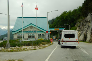
We stopped at U.S. Customs, had a brief chat with the border guard. He
 reminded us of the Maytag repairman who is always lonely. This was probably better duty than the inland Tok station, but it doesn’t look like a lot is happening in the Skagway area. A person has to want this duty to live in this relatively desolate country. Most border crossings are open 24 hours a day. The Skagway crossing is closed between midnight and 8 AM. If you want to cross, you just have to get in line and wait. Get there at a bit past midnight? You’ve got almost an eight-hour wait. That gives a whole new meaning to waiting. At home, we don’t even have to wait for a taco at Taco Bell. You have a craving for a burrito at two in the morning? Go get one. You want to cross the border at Skagway Alaska at two in the morning? Develop some patience.
We arrive at Skagway amid clouds and cool temperatures. In the harbor was one cruise ship. Tomorrow there will be three. It is clear that this town caters to cruise travelers. Streets are lined with jewelry stores and other gift shops. If you’ve ever taken a Caribbean cruise, you know how each port is filled with jewelry stores. This is Skagway. It is also peppered with historical storefronts, lots of restaurants and other tourist magn
 ets. For such a small town, it also boasts of four campgrounds. It has no chain hotels, but has a smattering of local monikers, including, get this, “Sergeant Preston Lodge”. No kidding.
We will tour Skagway tomorrow, hoping for better weather. We will also be investigating a ferry to Juneau. We want to photograph the 49th state’s capitol building and it will require some unusual travel to get there.

No comments:
Post a Comment